Address

Fildes Peninsula, King George Island.

Operated by the Chilean Antarctic Program.

Station manager

Andrés López

Contact Station


https://www.inach.cl/expedicion-antartica/bases-chilenas-en-antartica-2/base-profesor-julio-escudero/

Station Features

Opening year: 1995 Status: Open
  • Type of station: Station
  • Operational period: Year-round
  • Name of station owner: Chilean Antarctic Program
  • Type of owner: Government
  • Name of managing institution: Chilean Antarctic Program
  • Managing Institution Country: Chile
  • Station owner country: Chile
  • Partner institution: No
  • Station latitude: -62,20140000
  • Station longitude: 301,03780000
  • Region (station location): Antarctic Peninsula
  • Altitude of station: 10 m a.s.l
  • Type of surface facility is built on: Ice-free ground
  • Climate zone: Maritime Antarctica
  • Mean annual temperature: -2,3 °C
  • Mean temperature in February: 1,5 °C
  • Mean temperature in July: -6,4 °C
  • Precipitation type: Snow and rain
  • Snow free period (month to month): January-March
  • Sea ice break up: December
  • Dominant wind direction: Northwest
  • Geomorphological Coast, Hill, Lake, Melt streams, Moraine, Permanent snowpatches, Rock, Sea, Shoreline, Valley, Other
  • Wildlife Bird colonies, Seal colonies, Other biological
  • Antarctic Conservation Biogeographic Region North-west Antarctic Peninsula
  • Antarctic Environmental Domain Antarctic Peninsula offshore islands (e.g. most of Deception Island)

Facilities

  • Number of staff peak season/summer: 10
  • Number of staff off season/winter: 2
  • Area under roof: 4000 m²
  • Max. number of visitors at a time : 50
  • Showers: Yes
  • Laundry facilities: Yes
  • Power supply - period: 24 hours per day
  • Waste management: Yes
  • Hazard(ous) management: Yes
  • Logistics area: 760 m²
  • Conference room capacity: 50
  • Means of transportation to/from station Boat, Scheduled flight
  • Transport on land - at station Truck, Other
  • Transport on water - at station Zodiac
  • Water landing facilities None
  • Access: Air, Sea
  • Hydroponics facilities: No
  • Number of airstrips: 0
  • Helipad: Yes
  • Period of ship visits per year: January, February, March, October, November, December
  • Number of flight visit per year: 0
  • Period of flight visit per year: January, February, March, April, May, June, July, August, September, October, November, December
  • Laboratory equipment Microscopes, Basic laboratory equipment, Other
  • Laboratory area: 300 m²
  • Communications E-mail, Internet, Satellite telephone, Telephone, VHF

Science

  • Transnational Access: Yes
  • Remote Access: Yes
  • INTERACT Virtual Access: No
  • Partner institutions (involved in the operation of the station)
    • Partner institution
  • Climate
    • Snow
    • Rain
    • Hail
  • Landscape and environment
    • Bluff
    • Clear air zone
    • Coast
    • High elevation
    • Low artificial light pollution
    • Fjord
    • Hill
    • Low humidity
    • Lake
    • Other Atmospheric
    • Melt streams
    • Moraine
    • Mountain
    • Permanent snowpatches
    • Plateau
    • Rock
    • Sea
    • Shoreline
    • Terrestrial geothermal
    • Valley
    • Nunataks
    • Crevasse
    • Ice cap
    • Glacier
    • Blue ice
    • Ice shelf
    • Ice tongue
    • Sea-ice
    • Snow
    • Sustrugui
    • Other
    • Continuous
    • Discontinuous
    • Sporadic
    • None
    • Bird colonies
    • Seal colonies
    • Other biological
    • North-east Antarctic Peninsula
    • South Orkney Islands
    • North-west Antarctic Peninsula
    • Central south Antarctic Peninsula
    • Enderby Land
    • Dronning Maud Land
    • East Antarctica
    • North Victoria Land
    • South Victoria Land
    • Transantarctic Mountains
    • Ellsworth Mountains
    • Marie Byrd Land
    • Adelie Land
    • Ellsworth Land
    • South Antarctic Peninsula
    • Prince Charles Mountains
    • Antarctic Peninsula northern geologic
    • Antarctic Peninsula mid-northern latitudes geologic
    • Antarctic Peninsula southern geologic
    • East Antarctic coastal geologic (e.g. Vestfold, Bunger, Wilson hills)
    • Antarctic Peninsula, Alexander (and other islands main ice fields and glaciers)
    • Larsen Ice Shelf (also includes Prince Gustav and other northern peninsula ice shelf remnants)
    • Antarctic Peninsula offshore islands (e.g. most of Deception Island)
    • East Antarctic low latitude glacier tongues (e.g. Mertz, Rennick)
    • East Antarctic ice shelves (e.g. Fimbulisen, Amery, Shackleton, Cook, Moubray Bay)
    • Southern latitude coastal fringe ice shelves and floating glaciers (e.g. Pine Island,Thwaites, Getz, Drygalski)
    • Northern latitude ice shelves (e.g. Wordie, George VI, Wilkins, Abbot, Riser-Larsenisen, Nansen)
    • Continental coastal-zone ice sheet
    • Continental mid-latitude sloping ice (e.g. Ellsworth & Coats lands, upper Lambert Gl, northern Berkner & Thurston islands)
    • East Antarctic inland ice sheet
    • West Antarctic Ice Sheet (also includes inland Coats Land, Taylor Dome, Ross Island ice cap)
    • Ross and Ronne-Filchner ice shelves
    • East Antarctic high interior ice sheet
    • Transantarctic Mountains geologic (Shackleton Range to Cook Mountains)
    • McMurdo - South Victoria Land geologic (also includes Ellsworth, Werner etc mountains)
    • Inland continental geologic (Dronning Maud, MacRobertson, Victoria, Oates lands, Ford Range)
    • North Victoria Land geologic (also includes Executive Committee Range, Prince Charles & Jones mountains)
  • Housing and accomodation
    • Showers
    • Laundry facilities
    • Municipal grid
    • Diesel/oil/gas
    • Wood
    • Solar
    • Wind
    • Water
    • Geothermal
    • Biofuel
    • Other
    • Waste management
    • Hazard(ous) management
  • Logistics
    • Electrical and IT technologies
    • Mechanical
    • Metal
    • Wood
    • Plexiglas
    • Other
    • Walk
    • Tracked vehicle
    • Truck
    • SUV (4x4)
    • Car
    • Zodiac
    • ATV
    • Snowmobile
    • Open boat/Dhinghy
    • Bicycles
    • Closed boat
    • Amphibie vehicle
    • Ski
    • Other
    • Snow shoes
    • KickSledges
    • Other
    • Ski
    • Snowmobile
    • Boat
    • Car
    • Tracked vehicle
    • Truck
    • SUV (4x4)
    • Bus
    • Train
    • Scheduled flight
    • Chartered plane/helicopter
    • None
    • Other
    • Harbour/port
    • Warf/pier
    • Pontoon/float bridge
    • Barges
    • Beach
    • Hydroponics facilities
    • Helipad
  • Laboratory
    • Freezer < -80
    • Freezer -40 - -10
    • Fridge
    • Microscopes
    • Basic laboratory equipment
    • Advanced laboratory equipment
    • Basic chemical reagents
    • Analytical instrumentation
    • Other
  • Communication and IT
    • Computer
    • E-mail
    • Fax
    • Internet
    • Printer
    • Satellite telephone
    • Scanner
    • Telephone
    • VHF

Station name and owner

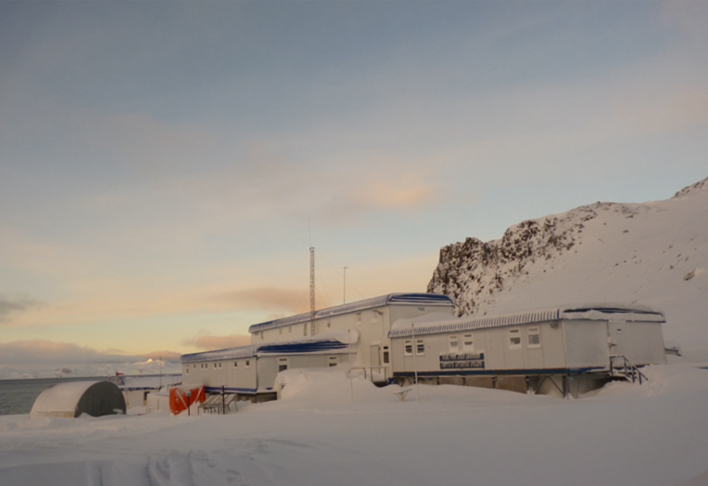
Professor Julio Escudero Station is owned by the Chilean Antarctic Program

Location

Professor Julio Escudero station is located on Fildes Peninsula, King George Island, Antarctic Specially Protected Area (ASPA) 125. Stations in the nearby area are Bellingshausen (Russia), Artigas (Uruguay), Great Wall Station (China), King Sejong (Korea) and Carlini (Argentina). Othere Chilean facility in the area are Collins, Fildes, Frei and Ripamonti.

Climate data

Grey colours are WMO Climate Normals including maximum and minimum values. Blue colours are individual years.

Export to PDF

Climate data for the stations where extracted via Copernicus Climate Data Store, from the global gridded reanalysis product:
ERA5 monthly averaged data on single levels from 1940 to present. Description and source code: Roemer J.K. 2023. https://doi.org/10.5281/zenodo.10214922 Data Source: Hersbach et al. 2023. Copernicus Climate Change Service (C3S) Climate Data Store (CDS), https://doi.org/10.24381/cds.f17050d7

Biodiversity and natural environment

An area near to the station, of 1.8 km2 in King George Island, was proposed by Chile as a Special Protection Area, on the basis of its uniqueness and paleontological richness. In this area, there are outcrops with fossils of a wide range of organisms, including vertebrates and invertebrates and abundant flora with impressions of leaves, stems, pollen grains and spores that date from the Upper Cretaceous to Eocene. The Cretaceous was a crucial time of vegetation change, mainly due to the evolutionary and geographic radiation of angiosperms. During the late Cretaceous, angiosperms infiltrated the pre-existing vegetation progressively, but gymnosperms, ferns and sphenophytes dominated terrestrial plant biomass until the Cenozoic. In addition, the Eocene represents the warmest time since the mass extinction at the end of the Cretaceous. The study of Fildes Peninsula outcrops could answer several important scientific questions.

History and facilities

During 1975, some containers were installed to support scientific studies being carried out in the area. The place was known as Refugio Fildes or Fildes station. It was expanded after 1990 with new modules. In 1994, the architecture works began for the first habitational module that was officially opened on February 5, 1995, with a ceremony led by the Director of INACH, Ambassador Oscar Pinochet de la Barra, and attended by several Chilean authorities. Currently, the facility has the capacity to accommodate sixty people, a multipurpose laboratory, a laboratory of microbiology and basic molecular biology, a wet lab, cold storage rooms and a divers working zone

General research and databases

Atmospheric, biological, environmental, palaeontology, geological research, geomorphology and glaciology studies are conducted at and near the station.

Station Monitoring

Human dimension

Access

Member of:
  • Polarin