Address

Greenwich Island, South Shetland Islands.

Operated by Chilean Navy.

Station manager

Andrés López

Contact Station


https://www.inach.cl/expedicion-antartica/bases-chilenas-en-antartica-2/base-naval-arturo-prat/

Station Features

Opening year: 0 Status: Open
  • Type of station: Station
  • Operational period: Year-round
  • Name of station owner: Chilean Antarctic Program
  • Type of owner: Government
  • Name of managing institution: Chilean Antarctic Program
  • Managing Institution Country: Chile
  • Station owner country: Chile
  • Partner institution: No
  • Station latitude: -62,47890000
  • Station longitude: 300,33560000
  • Region (station location): Antarctic Peninsula
  • Altitude of station: 0 m a.s.l
  • Type of surface facility is built on: Ice-free ground
  • Climate zone: Maritime Antarctica
  • Mean annual temperature: -2,3 °C
  • Mean temperature in February: 1,6 °C
  • Mean temperature in July: -6,7 °C
  • Precipitation type: Snow and rain
  • Snow free period (month to month): Jan-March
  • Sea ice break up: December
  • Dominant wind direction: Northwest
  • Mean annual wind speed: 42,1 m/s
  • Maximum wind speed (absolute): 92,6 m/s
  • Geomorphological Coast, Hill, Melt streams, Moraine, Rock, Sea, Shoreline, Other
  • Permafrost zone Discontinuous
  • Wildlife ,502,503,504
  • Antarctic Conservation Biogeographic Region North-west Antarctic Peninsula
  • Antarctic Environmental Domain Antarctic Peninsula offshore islands (e.g. most of Deception Island)

Facilities

  • Number of staff peak season/summer: 20
  • Number of staff off season/winter: 8
  • Area under roof: 1500 m²
  • Max. number of visitors at a time : 30
  • Showers: Yes
  • Laundry facilities: Yes
  • Power supply - period: 24 hours per day
  • Power sources at station Diesel/oil/gas
  • Waste management: Yes
  • Hazard(ous) management: Yes
  • Logistics area: 500 m²
  • Conference room capacity: 20
  • Workshops Mechanical, Metal, Wood
  • Means of transportation to/from station Boat, Chartered plane/helicopter
  • Transport on land - at station Other
  • Transport on water - at station Zodiac
  • Water landing facilities Warf/pier
  • Access: Air, Sea
  • Number of airstrips: 0
  • Helipad: Yes
  • Number of ship visits per year: 10
  • Period of ship visits per year: January, February, March, October, November, December
  • Laboratory area: 150 m²
  • Laboratory equipment Freezer -40 - -10, Microscopes, Basic laboratory equipment, Other
  • Medical facilities: Yes
  • Medical capability Basic
  • Distance to hospital (km): 1000
  • Area of medical facilities (m2): 14 m²
  • Closest emergency facility in Antarctica: 0 km
  • Closest emergency facility external: 1000 km

Science

  • Transnational Access: Yes
  • Remote Access: No
  • INTERACT Virtual Access: No
  • Partner institutions (involved in the operation of the station)
    • Partner institution
  • Climate
    • Snow
    • Rain
    • Hail
  • Landscape and environment
    • Bluff
    • Clear air zone
    • Coast
    • High elevation
    • Low artificial light pollution
    • Fjord
    • Hill
    • Low humidity
    • Other Atmospheric
    • Lake
    • Melt streams
    • Moraine
    • Mountain
    • Permanent snowpatches
    • Plateau
    • Rock
    • Sea
    • Shoreline
    • Terrestrial geothermal
    • Valley
    • Nunataks
    • Crevasse
    • Ice cap
    • Glacier
    • Blue ice
    • Ice shelf
    • Ice tongue
    • Sea-ice
    • Snow
    • Sustrugui
    • Other
    • Continuous
    • Discontinuous
    • Sporadic
    • None
    • Bird colonies
    • Seal colonies
    • Other biological
    • North-east Antarctic Peninsula
    • South Orkney Islands
    • North-west Antarctic Peninsula
    • Central south Antarctic Peninsula
    • Enderby Land
    • Dronning Maud Land
    • East Antarctica
    • North Victoria Land
    • South Victoria Land
    • Transantarctic Mountains
    • Ellsworth Mountains
    • Marie Byrd Land
    • Adelie Land
    • Ellsworth Land
    • South Antarctic Peninsula
    • Prince Charles Mountains
    • Antarctic Peninsula northern geologic
    • Antarctic Peninsula mid-northern latitudes geologic
    • Antarctic Peninsula southern geologic
    • East Antarctic coastal geologic (e.g. Vestfold, Bunger, Wilson hills)
    • Antarctic Peninsula, Alexander (and other islands main ice fields and glaciers)
    • Larsen Ice Shelf (also includes Prince Gustav and other northern peninsula ice shelf remnants)
    • Antarctic Peninsula offshore islands (e.g. most of Deception Island)
    • East Antarctic low latitude glacier tongues (e.g. Mertz, Rennick)
    • East Antarctic ice shelves (e.g. Fimbulisen, Amery, Shackleton, Cook, Moubray Bay)
    • Southern latitude coastal fringe ice shelves and floating glaciers (e.g. Pine Island,Thwaites, Getz, Drygalski)
    • Northern latitude ice shelves (e.g. Wordie, George VI, Wilkins, Abbot, Riser-Larsenisen, Nansen)
    • Continental coastal-zone ice sheet
    • Continental mid-latitude sloping ice (e.g. Ellsworth & Coats lands, upper Lambert Gl, northern Berkner & Thurston islands)
    • East Antarctic inland ice sheet
    • West Antarctic Ice Sheet (also includes inland Coats Land, Taylor Dome, Ross Island ice cap)
    • Ross and Ronne-Filchner ice shelves
    • East Antarctic high interior ice sheet
    • Transantarctic Mountains geologic (Shackleton Range to Cook Mountains)
    • McMurdo - South Victoria Land geologic (also includes Ellsworth, Werner etc mountains)
    • Inland continental geologic (Dronning Maud, MacRobertson, Victoria, Oates lands, Ford Range)
    • North Victoria Land geologic (also includes Executive Committee Range, Prince Charles & Jones mountains)
  • Housing and accomodation
    • Showers
    • Laundry facilities
    • Municipal grid
    • Diesel/oil/gas
    • Wood
    • Solar
    • Wind
    • Water
    • Geothermal
    • Biofuel
    • Other
    • Waste management
    • Hazard(ous) management
  • Logistics
    • Electrical and IT technologies
    • Mechanical
    • Metal
    • Wood
    • Plexiglas
    • Other
    • Walk
    • Tracked vehicle
    • Truck
    • SUV (4x4)
    • Car
    • Zodiac
    • ATV
    • Snowmobile
    • Open boat/Dhinghy
    • Closed boat
    • Bicycles
    • Amphibie vehicle
    • Ski
    • Other
    • Snow shoes
    • KickSledges
    • Other
    • Ski
    • Snowmobile
    • Boat
    • Car
    • Tracked vehicle
    • Truck
    • SUV (4x4)
    • Bus
    • Train
    • Scheduled flight
    • Chartered plane/helicopter
    • None
    • Other
    • Harbour/port
    • Warf/pier
    • Pontoon/float bridge
    • Barges
    • Beach
    • Hydroponics facilities
    • Helipad
  • Laboratory
    • Freezer < -80
    • Freezer -40 - -10
    • Fridge
    • Microscopes
    • Basic laboratory equipment
    • Advanced laboratory equipment
    • Basic chemical reagents
    • Analytical instrumentation
    • Other
  • Medical facilities
    • Medical facilities
    • Basic
    • Medium
    • Extensive
    • Dental
    • Surgery
    • Other
    • Aeromedical equipment
    • Altitude medicine
    • Anaesthesia
    • Biochemistry
    • Blood transfusion medicine
    • Diagnostic X-ray
    • Diagnostic ultrasound
    • Endoscopy
    • Haematology
    • Hyperbaric recompression chamber
    • Laboratory diagnostics
    • Microbiology
    • Ophthalmology
    • Telemedicine
    • Other
    • Staff with basic medical training or doctor (Summer)
    • Staff with basic medical training or doctor (Winter)
    • Medical research capabilities
    • Medical screening requirements

Station name and owner

The Captain Arturo Prat Navy Station is owned by the Chilean Antarctic Program and operated by the Chilean Navy.

Location

The scientific laboratory is located at Arturo Prat station, run by the Chilean Navy, Greenwich Island, South Shetland Islands. Antarctic Specially Protected Area (ASPA) 144, is in the area nearby the station.

Climate data

Grey colours are WMO Climate Normals including maximum and minimum values. Blue colours are individual years.

Export to PDF

Climate data for the stations where extracted via Copernicus Climate Data Store, from the global gridded reanalysis product:
ERA5 monthly averaged data on single levels from 1940 to present. Description and source code: Roemer J.K. 2023. https://doi.org/10.5281/zenodo.10214922 Data Source: Hersbach et al. 2023. Copernicus Climate Change Service (C3S) Climate Data Store (CDS), https://doi.org/10.24381/cds.f17050d7

Biodiversity and natural environment

Geology, glaciology, microbiology and marine biology studies are performed at and in the area near the station.

History and facilities

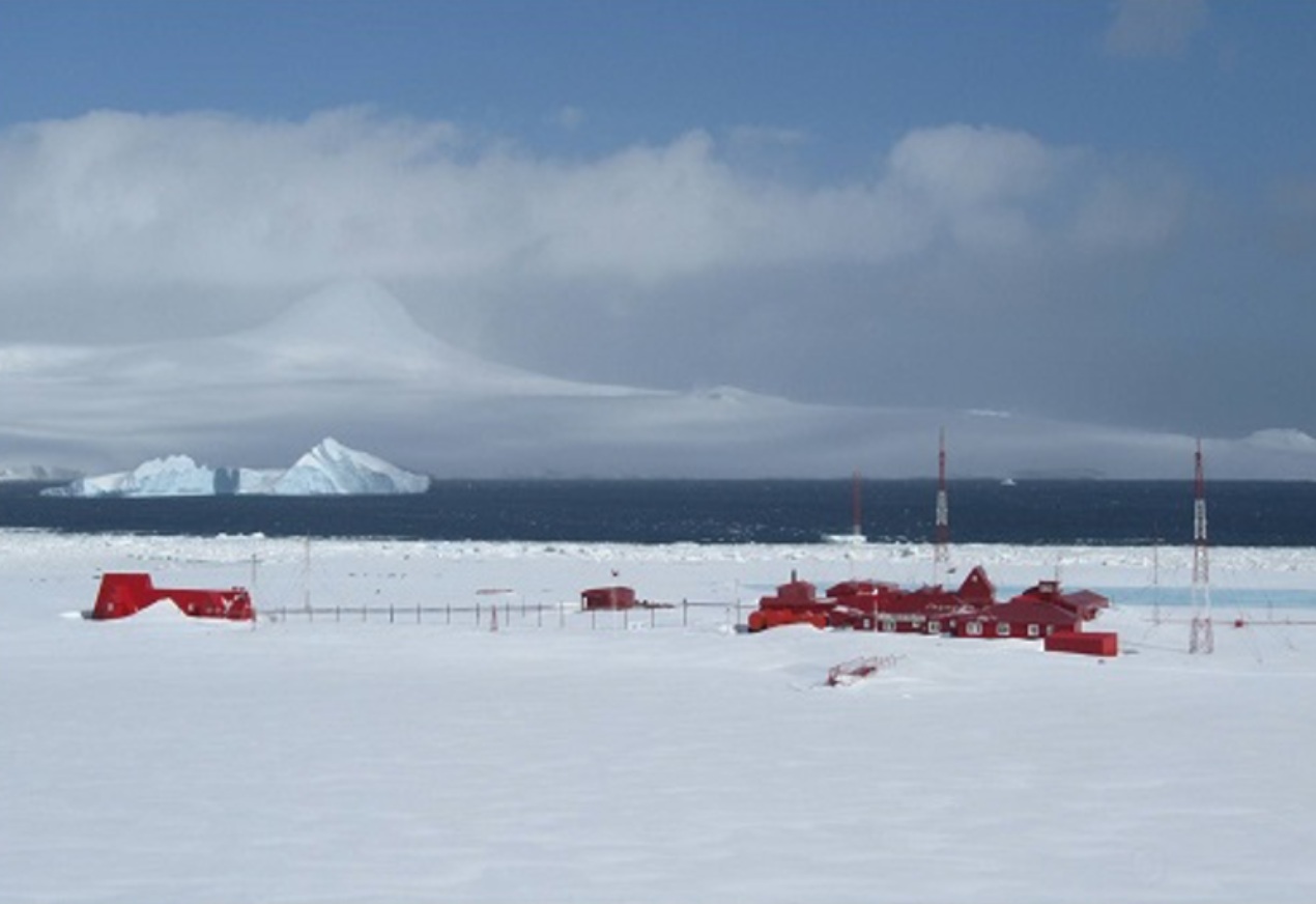
Arturo Prat station was opened on February 6, 1947 by the First Chilean Antarctic Expedition and it has been established in Iquique Cove, Chile Bay (Discovery Bay), Greenwich Island, South Shetlands Islands. It is named after Captain Arturo Prat, the most important Chilean naval hero. Since its opening, the Chilean Navy has run the Station; the Chilean Antarctic Institute built laboratory facilities and bedrooms for scientists at the site. Four sites at and nearby the station have been designated Historic Sites and Monuments (HSM) 32, 33, 34 and 35, following Chile’s proposals to the Antarctic Treaty Consultative Meetings.

General research and databases

Land and marine biology, microbiology, geology and glaciology studies have been performed at and near the station. Results of the research are published in ISI and WOS refereed magazines and can therefore be searched using appropriate keywords and available searching tools. At earlier times research was published mainly in the Instituto Antártico Chileno’s (INACH) Serie Científica. Station’s research outreach papers have also been published in the INACH Boletín Antártico Chileno and ILAIA magazines.

Station Monitoring

Human dimension

Access

Member of:
  • Polarin