Address

Deception Island, South Shetland Islands.

Operated by the Comité Polar Español (Spain Polar Committee).

Station manager

Antonio Quesada and Constantino Fernandez

Contact Station


https://ejercito.defensa.gob.es/unidades/Antartica/basegabrieldecastilla/index.html

Station Features

Opening year: 1998 Status: Open
  • Type of station: Station
  • Operational period: November - March
  • Name of station owner: Comité Polar Español
  • Type of owner: Government
  • Name of managing institution: Comité Polar Español
  • Managing Institution Country: Spain
  • Station owner country: Spain
  • Partner institution: No
  • Station latitude: -62,97690000
  • Station longitude: 299,32470000
  • Region (station location): Antarctic Peninsula
  • Altitude of station: 15 m a.s.l
  • Type of surface facility is built on: Ice-free ground
  • Climate zone: Maritime Antarctica
  • Mean annual temperature: -0,7 °C
  • Mean temperature in February: 2,6 °C
  • Mean temperature in July: -6,9 °C
  • Precipitation type: Snow and rain
  • Snow free period (month to month): January - March
  • Sea ice break up: November
  • Mean annual wind speed: 24 m/s
  • Maximum wind speed (absolute): 130 m/s
  • Geomorphological Coast, Lake, Mountain, Permanent snowpatches, Rock, Terrestrial geothermal
  • Permafrost zone Discontinuous
  • Wildlife Bird colonies, Seal colonies
  • Antarctic Conservation Biogeographic Region North-west Antarctic Peninsula
  • Antarctic Environmental Domain Antarctic Peninsula offshore islands (e.g. most of Deception Island)

Facilities

  • Number of staff peak season/summer: 13
  • Area under roof: 792 m²
  • Max. number of visitors at a time : 36
  • Showers: Yes
  • Laundry facilities: Yes
  • Power supply - period: 24 hours per day
  • Power sources at station Diesel/oil/gas, Other
  • Waste management: Yes
  • Hazard(ous) management: Yes
  • Logistics area: 650 m²
  • Conference room capacity: 36
  • Workshops Electrical and IT technologies, Mechanical, Metal
  • Means of transportation to/from station Boat, Chartered plane/helicopter
  • Transport on land - at station ATV, Other
  • Transport on water - at station Open boat/Dhinghy
  • Water landing facilities Pontoon/float bridge
  • Access: Sea
  • Number of airstrips: 0
  • Number of ship visits per year: 100
  • Period of ship visits per year: January, February, March, November, December
  • Number of flight visit per year: 0
  • Specific device/Scientific equipment: Specific device/Scientific equipment: Environment and Food Safety Lab Equipment, one Gas Detector, one Ground Sampling Equipment, one Multiparameter Photometer Spectroquant Nova 30A, one Thermostat Lt 200, Three Pumps for Microbiological Testing
  • Laboratory area: 142 m²
  • Laboratory equipment Basic laboratory equipment, Analytical instrumentation
  • Communications Computer, E-mail, Fax, Internet, Printer, Satellite telephone, Scanner, Telephone, VHF
  • Medical facilities: Yes
  • Medical capability Basic, Dental
  • Distance to hospital (km): 0
  • Area of medical facilities (m2): 15 m²
  • Medical equipment Anaesthesia, Biochemistry, Diagnostic ultrasound, Telemedicine
  • Staff with basic medical training or doctor (Summer): Yes
  • Closest emergency facility in Antarctica: 0 km

Science

  • Transnational Access: Yes
  • Remote Access: No
  • INTERACT Virtual Access: No
  • Partner institutions (involved in the operation of the station)
    • Partner institution
  • Climate
    • Snow
    • Rain
    • Hail
  • Landscape and environment
    • Bluff
    • Clear air zone
    • Coast
    • High elevation
    • Low artificial light pollution
    • Fjord
    • Low humidity
    • Hill
    • Lake
    • Other Atmospheric
    • Melt streams
    • Moraine
    • Mountain
    • Permanent snowpatches
    • Plateau
    • Rock
    • Sea
    • Shoreline
    • Terrestrial geothermal
    • Valley
    • Nunataks
    • Crevasse
    • Ice cap
    • Glacier
    • Blue ice
    • Ice shelf
    • Ice tongue
    • Sea-ice
    • Snow
    • Sustrugui
    • Other
    • Continuous
    • Discontinuous
    • Sporadic
    • None
    • Bird colonies
    • Seal colonies
    • Other biological
    • North-east Antarctic Peninsula
    • South Orkney Islands
    • North-west Antarctic Peninsula
    • Central south Antarctic Peninsula
    • Enderby Land
    • Dronning Maud Land
    • East Antarctica
    • North Victoria Land
    • South Victoria Land
    • Transantarctic Mountains
    • Ellsworth Mountains
    • Marie Byrd Land
    • Adelie Land
    • Ellsworth Land
    • South Antarctic Peninsula
    • Prince Charles Mountains
    • Antarctic Peninsula northern geologic
    • Antarctic Peninsula mid-northern latitudes geologic
    • Antarctic Peninsula southern geologic
    • East Antarctic coastal geologic (e.g. Vestfold, Bunger, Wilson hills)
    • Antarctic Peninsula, Alexander (and other islands main ice fields and glaciers)
    • Larsen Ice Shelf (also includes Prince Gustav and other northern peninsula ice shelf remnants)
    • Antarctic Peninsula offshore islands (e.g. most of Deception Island)
    • East Antarctic low latitude glacier tongues (e.g. Mertz, Rennick)
    • East Antarctic ice shelves (e.g. Fimbulisen, Amery, Shackleton, Cook, Moubray Bay)
    • Southern latitude coastal fringe ice shelves and floating glaciers (e.g. Pine Island,Thwaites, Getz, Drygalski)
    • Northern latitude ice shelves (e.g. Wordie, George VI, Wilkins, Abbot, Riser-Larsenisen, Nansen)
    • Continental coastal-zone ice sheet
    • Continental mid-latitude sloping ice (e.g. Ellsworth & Coats lands, upper Lambert Gl, northern Berkner & Thurston islands)
    • East Antarctic inland ice sheet
    • West Antarctic Ice Sheet (also includes inland Coats Land, Taylor Dome, Ross Island ice cap)
    • Ross and Ronne-Filchner ice shelves
    • East Antarctic high interior ice sheet
    • Transantarctic Mountains geologic (Shackleton Range to Cook Mountains)
    • McMurdo - South Victoria Land geologic (also includes Ellsworth, Werner etc mountains)
    • Inland continental geologic (Dronning Maud, MacRobertson, Victoria, Oates lands, Ford Range)
    • North Victoria Land geologic (also includes Executive Committee Range, Prince Charles & Jones mountains)
  • Housing and accomodation
    • Showers
    • Laundry facilities
    • Municipal grid
    • Diesel/oil/gas
    • Wood
    • Solar
    • Wind
    • Water
    • Geothermal
    • Biofuel
    • Other
    • Waste management
    • Hazard(ous) management
  • Logistics
    • Electrical and IT technologies
    • Mechanical
    • Metal
    • Wood
    • Plexiglas
    • Other
    • Walk
    • Tracked vehicle
    • Truck
    • SUV (4x4)
    • Car
    • ATV
    • Zodiac
    • Open boat/Dhinghy
    • Snowmobile
    • Closed boat
    • Bicycles
    • Amphibie vehicle
    • Ski
    • Other
    • Snow shoes
    • KickSledges
    • Other
    • Ski
    • Snowmobile
    • Boat
    • Car
    • Tracked vehicle
    • Truck
    • SUV (4x4)
    • Bus
    • Train
    • Scheduled flight
    • Chartered plane/helicopter
    • None
    • Other
    • Harbour/port
    • Warf/pier
    • Pontoon/float bridge
    • Barges
    • Beach
    • Hydroponics facilities
    • Helipad
  • Laboratory
    • Freezer < -80
    • Freezer -40 - -10
    • Fridge
    • Microscopes
    • Basic laboratory equipment
    • Advanced laboratory equipment
    • Basic chemical reagents
    • Analytical instrumentation
    • Other
  • Communication and IT
    • Computer
    • E-mail
    • Fax
    • Internet
    • Printer
    • Satellite telephone
    • Scanner
    • Telephone
    • VHF
  • Medical facilities
    • Medical facilities
    • Basic
    • Medium
    • Extensive
    • Dental
    • Surgery
    • Other
    • Aeromedical equipment
    • Altitude medicine
    • Anaesthesia
    • Biochemistry
    • Blood transfusion medicine
    • Diagnostic X-ray
    • Diagnostic ultrasound
    • Endoscopy
    • Haematology
    • Hyperbaric recompression chamber
    • Laboratory diagnostics
    • Microbiology
    • Ophthalmology
    • Telemedicine
    • Other
    • Staff with basic medical training or doctor (Summer)
    • Staff with basic medical training or doctor (Winter)
    • Medical research capabilities
    • Medical screening requirements

Station name and owner

The Spanish Antarctic Station “Gabriel de Castilla” is owned and operated by the Comité Polar Español.

Location

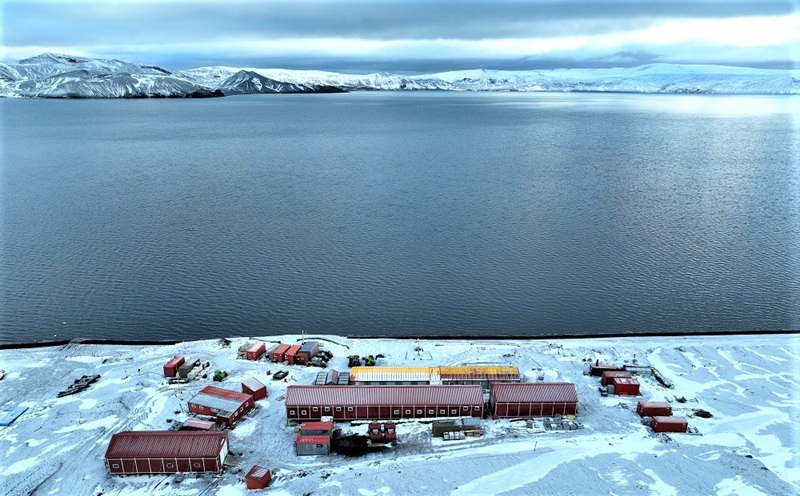
The station is located on Deception Island, South Shetland Islands. It is a summer station opened, normally, from November to March.

Climate data

Grey colours are WMO Climate Normals including maximum and minimum values. Blue colours are individual years.

Export to PDF

Climate data for the stations where extracted via Copernicus Climate Data Store, from the global gridded reanalysis product:
ERA5 monthly averaged data on single levels from 1940 to present. Description and source code: Roemer J.K. 2023. https://doi.org/10.5281/zenodo.10214922 Data Source: Hersbach et al. 2023. Copernicus Climate Change Service (C3S) Climate Data Store (CDS), https://doi.org/10.24381/cds.f17050d7

Biodiversity and natural environment

The area is located in an active volcano, and there is a unique community of organisms adapted to the geothermal activity. It is remarkably rich in criptogamic communities. There are several penguin rookeries. Over 57% of the island is covered by permanent glaciers. A ring of hills runs around the island and is the principal drainage divide, ephemeral springs flow toward the inner and outer coast. Several lakes are located on the interior side of the watershed. Kroner Lake is the only geothermal lagoon in the Antarctic.

History and facilities

The area has had a long history of human activity since about 1820, including exploration, sealing, whaling, aviation and scientific research. Deception Island is one of the few places in the world where vessels can sail directly into the centre of a restless volcanic caldera, providing the opportunity for visitors to learn about volcanoes and other aspects of the natural world, as well as early Antarctic exploration, whaling and science. Deception Island is also one of the most frequently visited sites in Antarctica by tourists. The island is an Antarctic Specially Managed Area (ASMA 4), with two Antarctic Specially Protected Areas ASPA140 and ASPA145. The station Gabriel de Castilla was set up as refuge in 1990 mainly to support the scientific research carried out by Spain in Deception Island. The interest in the natural values of the island was increasing among the scientific community and, at the same time, the requests to develop research projects with the support of Gabriel de Castilla refuge. Due to the improvement of its capabilities, in 1998 Gabriel de Castilla was designated formally as a station. Nowadays, the station Gabriel de Castilla provides a very good living and working conditions with livingroom with kitchen and bakery. There are also seven sleeping room with four beds each and one laundry room. A scientist semi-permanent building with two offices, two labs, one environment issues lab (equipped) and a bathroom. Other facilities include a ribbon boat store container, nautical equipment store container, two materials of facilities container, wet lab container, health container (infirmary container), workshop building, three building igloos, logistic stores containers, freezer container, incinerator and communications area.

General research and databases

Databases on volcanism, seismology, marine biology, limnology, permafrost and meteorology are maintained. Research on coastal biology, pollution, human impact, invasive species.

Station Monitoring

Human dimension

Access

Member of:
  • Polarin