Address

Victoria Land, Antarctica

Operted by Programma Nazionale di Ricerche in Antartide
ENEA (Italian National Agency for New Technologies, Energy and Sustainable Economic Development)

Station manager

Maurizio Azzaro

Contact Station

Phone: +39 041 2348547

http://www.italiantartide.it/stazione-mario-zucchelli

Station Features

Opening year: 1986 Status: Open
  • Type of station: Station
  • Operational period: October-February
  • Name of station owner: Programma Nazionale di Ricerche in Antartide
  • Type of owner: Government
  • Name of managing institution: Programma Nazionale di Ricerche in Antartide
  • Managing Institution Country: Italy
  • Station owner country: Italy
  • Partner institution: No
  • Station latitude: -74,69420000
  • Station longitude: 164,11390000
  • Region (station location): Continental Antarctica
  • Altitude of station: 15 m a.s.l
  • Type of surface facility is built on: Ice-free ground
  • Climate zone: Coastal Antarctica
  • Mean annual temperature: -14 °C
  • Mean temperature in February: -7 °C
  • Mean temperature in July: -22 °C
  • Precipitation type: Snow
  • Snow free period (month to month): January, December
  • Sea ice break up: December
  • Dominant wind direction: West
  • Mean annual wind speed: 6,1 m/s
  • Maximum wind speed (absolute): 67,5 m/s
  • Geomorphological Bluff, Hill, Lake, Melt streams, Moraine, Mountain, Permanent snowpatches, Plateau, Rock, Sea, Shoreline, Valley, Other
  • Atmospheric Clear air zone, High elevation, Low artificial light pollution, Low humidity
  • Permafrost zone Continuous
  • Wildlife Bird colonies, Seal colonies, Other biological
  • Antarctic Conservation Biogeographic Region North Victoria Land
  • Antarctic Environmental Domain North Victoria Land geologic (also includes Executive Committee Range, Prince Charles & Jones mountains)

Facilities

  • Number of staff peak season/summer: 80
  • Area under roof: 7500 m²
  • Max. number of visitors at a time : 120
  • Showers: Yes
  • Laundry facilities: Yes
  • Power supply - period: 24 hours
  • Power sources at station Diesel/oil/gas
  • Waste management: Yes
  • Hazard(ous) management: Yes
  • Logistics area: 5100 m²
  • Conference room capacity: 100
  • Workshops Electrical and IT technologies, Mechanical, Metal, Wood, Plexiglas, Other
  • Means of transportation to/from station Boat, Chartered plane/helicopter
  • Transport on land - at station Tracked vehicle, Truck, ATV, Snowmobile, Other
  • Transport on water - at station Zodiac, Open boat/Dhinghy
  • Water landing facilities Pontoon/float bridge
  • Access: Air, Land
  • Hydroponics facilities: Yes
  • Number of airstrips: 4
  • Length (m) of longest runway: 3000
  • Width (m) of longest runway: 70
  • Helipad: Yes
  • Number of ship visits per year: 1
  • Period of ship visits per year: January
  • Number of flight visit per year: 20
  • Period of flight visit per year: January, February, October, November, December
  • Specific device/Scientific equipment: The station has several research facilities that include helicopters, boats (a 15 m oceanographic vessel and six rubber-dinghies), terrestrial cross-country vehicles (mainly as support of scientific activities in remote areas) and common laboratories. Scientific services possible: Along with helicopter and airplane services for remote field research, a diving research service is available as well, allowed by the regular presence on field of professional divers. For this purpose a hyperbaric chamber is available at MZS. Long-term monitoring/observations: Long-term monitoring and observations consist of: five year-round automatic observatories (geomagnetism, ionosphere, seismology, space weather and surface radiative fluxes), the Meteo-climatic PNRA AWS network (since 1987), the permafrost active layer monitoring CALM grid (since 2000), the long-term monitoring of Adélie penguin colonies at Adélie Cove and of silver fish reproduction at Terra Nova Bay.
  • Laboratory area: 2400 m²
  • Laboratory equipment Other
  • Communications Computer, E-mail, Fax, Internet, Printer, Satellite telephone, Scanner, Telephone, VHF
  • Medical facilities: Yes
  • Medical capability Basic, Dental, Surgery
  • Distance to hospital (km): 0
  • Area of medical facilities (m2): 60 m²
  • Medical equipment Surgical theatre, Traumatology, Portable field X-ray
  • Staff with basic medical training or doctor (Summer): Yes
  • Closest emergency facility in Antarctica: 360 km
  • Closest emergency facility external: 3500 km
  • Medical screening requirements: Yes

Science

  • Transnational Access: Yes
  • Remote Access: Yes
  • INTERACT Virtual Access: No
  • Housing and accomodation
    • Showers
    • Laundry facilities
    • Municipal grid
    • Diesel/oil/gas
    • Wood
    • Solar
    • Wind
    • Water
    • Geothermal
    • Biofuel
    • Other
    • Waste management
    • Hazard(ous) management
  • Logistics
    • Electrical and IT technologies
    • Mechanical
    • Metal
    • Wood
    • Plexiglas
    • Other
    • Walk
    • Tracked vehicle
    • Truck
    • SUV (4x4)
    • Car
    • ATV
    • Zodiac
    • Snowmobile
    • Open boat/Dhinghy
    • Closed boat
    • Bicycles
    • Amphibie vehicle
    • Ski
    • Other
    • Snow shoes
    • KickSledges
    • Other
    • Ski
    • Snowmobile
    • Boat
    • Car
    • Tracked vehicle
    • Truck
    • SUV (4x4)
    • Bus
    • Train
    • Scheduled flight
    • Chartered plane/helicopter
    • None
    • Other
    • Harbour/port
    • Warf/pier
    • Pontoon/float bridge
    • Barges
    • Beach
    • Hydroponics facilities
    • Helipad
  • Laboratory
    • Freezer < -80
    • Freezer -40 - -10
    • Fridge
    • Microscopes
    • Basic laboratory equipment
    • Advanced laboratory equipment
    • Basic chemical reagents
    • Analytical instrumentation
    • Other
  • Communication and IT
    • Computer
    • E-mail
    • Fax
    • Internet
    • Printer
    • Satellite telephone
    • Scanner
    • Telephone
    • VHF
  • Medical facilities
    • Medical facilities
    • Basic
    • Medium
    • Extensive
    • Dental
    • Surgery
    • Other
    • Aeromedical equipment
    • Altitude medicine
    • Anaesthesia
    • Biochemistry
    • Blood transfusion medicine
    • Diagnostic X-ray
    • Diagnostic ultrasound
    • Endoscopy
    • Haematology
    • Hyperbaric recompression chamber
    • Laboratory diagnostics
    • Microbiology
    • Ophthalmology
    • Telemedicine
    • Other
    • Staff with basic medical training or doctor (Summer)
    • Staff with basic medical training or doctor (Winter)
    • Medical research capabilities
    • Medical screening requirements
  • Climate
    • Snow
    • Rain
    • Hail
  • Landscape and environment
    • Bluff
    • Clear air zone
    • High elevation
    • Coast
    • Low artificial light pollution
    • Fjord
    • Low humidity
    • Hill
    • Lake
    • Other Atmospheric
    • Melt streams
    • Moraine
    • Mountain
    • Permanent snowpatches
    • Plateau
    • Rock
    • Sea
    • Shoreline
    • Terrestrial geothermal
    • Valley
    • Nunataks
    • Crevasse
    • Ice cap
    • Glacier
    • Blue ice
    • Ice shelf
    • Ice tongue
    • Sea-ice
    • Snow
    • Sustrugui
    • Other
    • Continuous
    • Discontinuous
    • Sporadic
    • None
    • Bird colonies
    • Seal colonies
    • Other biological
    • North-east Antarctic Peninsula
    • South Orkney Islands
    • North-west Antarctic Peninsula
    • Central south Antarctic Peninsula
    • Enderby Land
    • Dronning Maud Land
    • East Antarctica
    • North Victoria Land
    • South Victoria Land
    • Transantarctic Mountains
    • Ellsworth Mountains
    • Marie Byrd Land
    • Adelie Land
    • Ellsworth Land
    • South Antarctic Peninsula
    • Prince Charles Mountains
    • Antarctic Peninsula northern geologic
    • Antarctic Peninsula mid-northern latitudes geologic
    • Antarctic Peninsula southern geologic
    • East Antarctic coastal geologic (e.g. Vestfold, Bunger, Wilson hills)
    • Antarctic Peninsula, Alexander (and other islands main ice fields and glaciers)
    • Larsen Ice Shelf (also includes Prince Gustav and other northern peninsula ice shelf remnants)
    • Antarctic Peninsula offshore islands (e.g. most of Deception Island)
    • East Antarctic low latitude glacier tongues (e.g. Mertz, Rennick)
    • East Antarctic ice shelves (e.g. Fimbulisen, Amery, Shackleton, Cook, Moubray Bay)
    • Southern latitude coastal fringe ice shelves and floating glaciers (e.g. Pine Island,Thwaites, Getz, Drygalski)
    • Northern latitude ice shelves (e.g. Wordie, George VI, Wilkins, Abbot, Riser-Larsenisen, Nansen)
    • Continental coastal-zone ice sheet
    • Continental mid-latitude sloping ice (e.g. Ellsworth & Coats lands, upper Lambert Gl, northern Berkner & Thurston islands)
    • East Antarctic inland ice sheet
    • West Antarctic Ice Sheet (also includes inland Coats Land, Taylor Dome, Ross Island ice cap)
    • Ross and Ronne-Filchner ice shelves
    • East Antarctic high interior ice sheet
    • Transantarctic Mountains geologic (Shackleton Range to Cook Mountains)
    • McMurdo - South Victoria Land geologic (also includes Ellsworth, Werner etc mountains)
    • Inland continental geologic (Dronning Maud, MacRobertson, Victoria, Oates lands, Ford Range)
    • North Victoria Land geologic (also includes Executive Committee Range, Prince Charles & Jones mountains)
  • Partner institutions (involved in the operation of the station)
    • Partner institution

Station name and owner

The Mario Zuchelli Station os operated by Programma Nazionale di Ricerche in Antartide.

Location

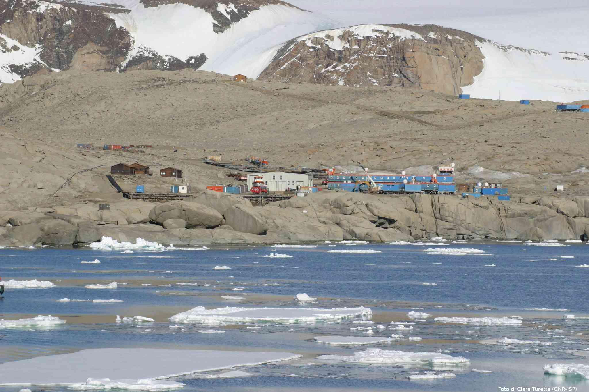
Mario Zucchelli station (MZS) is located in the Ross Sea area, in the Victoria Land, at the foot of small range called Northern Foothills. MZS is a coastal station built on a granite promontory overlooking the Gerlache Inlet, within the wider Terra Nova Bay.

Climate data

Grey colours are WMO Climate Normals including maximum and minimum values. Blue colours are individual years.

Export to PDF

Climate data for the stations where extracted via Copernicus Climate Data Store, from the global gridded reanalysis product:
ERA5 monthly averaged data on single levels from 1940 to present. Description and source code: Roemer J.K. 2023. https://doi.org/10.5281/zenodo.10214922 Data Source: Hersbach et al. 2023. Copernicus Climate Change Service (C3S) Climate Data Store (CDS), https://doi.org/10.24381/cds.f17050d7

Biodiversity and natural environment

MZS is located in the Northern Foothills, an ice-marginal, high latitude periglacial environment covered only by local glaciers and snowfields. The area, characterized by Adélie and Emperor penguin colonies and Skua colonies (at Edmonson Point, Cape Washington, Adélie Cove and Inexpressible Island), hosts some marine and terrestrial protected areas (ASPA161, 118 and 173). The fauna comprises also other species of seabirds (Snow and Wilson’s Storm petrel), seals (Leopard and Weddell seal) and whales (Killer, Antarctic minke and Arnoux’s beaked whale). Furthermore Wood Bay and Terra Nova Bay are among the most biologically and ecologically diverse areas in Antarctica with many species of bryophytes, lichens, algae, cyanobacteria and invertebrates. The vegetation of Victoria Land is entirely cryptogamic and vascular plants are absent.

History and facilities

The site for the permanent Italian station, built in 1986, is Terra Nova Bay between Cape Washington and the Drygalski Ice Tongue, along the coast of Northern Victoria Land. The station was called Baia Terra Nova until 2004. The station is built right on the shore, on a granite rocky peninsula with a north-south orientation. The area assigned to the buildings provides easy access from/to the sea from both east and west. The small inlet on the east shore is particularly suited for unloading cargo at the beginning of the season, when the sea is totally covered with ice. The fast-ice in Tethys Bay is used at the beginning of the season as an aircraft landing place. The main facilities are runways, helipads, plants (power production, incinerator, waste water treatment, desalinator, liquefier), fuel storage and aquarium.

General research and databases

Terra Nova Bay area has been widely scientifically investigated in the last thirty-two years, through extensive geological, oceanographic, marine, ecological and biological research. Marine biological research activities were carried out in the area during the austral summers since the early 1990s including fish community dynamics (in particular the Silver fish). Since 1987, the Meteo-Climatological Observatory of the Programma Nazionale di Ricerche in Antartide (PNRA) has collected meteorological data by means of several automatic weather stations (over thirty at present) installed in the Victoria Land region. Measurements of the size of Adélie penguin colonies of the southern Ross Sea since 1984 are among the longest biologic time series in Antarctica. At Boulder Clay, since 2000, an automatic station (CALM protocol grid) is monitoring the permafrost thermal regime.

Station Monitoring

Human dimension

Access

Member of:
  • Polarin